HALO AC3

(AC)³ Project A02 – Tethered balloon-borne energy budget measurements in the cloudy central Arctic

PIs: Holger Siebert (TROPOS), Manfred Wendisch (Uni Leipzig) Contributor:

Within the A02 project in (AC)³ measurements with the tethered-balloon system BELUGA (Balloon-bornE moduLar Utility for profilinG the lower Atmosphere) were performed in the cloudy Arctic boundary layer. By extending observations with BELUGA at the AWIPEV station in Ny-Ålesund, Spitzbergen, the measurements will close a significant gap in the existing observations made during ice flow campaigns in the central Arctic during summer. The observations will enable to exploit the full potential of the BELUGA system by obtaining a longer-term time series of data mostly directed to obtain data for process studies.

BELUGA system from TROPOS during ice camp observation (Photo: Michael Lonardi, Uni Leipzig, 2020). The balloon will be operated from AWIPEV station at Ny-Ålesund (Spitzbergen) during HALO-(AC)³.

With the suggested statistical approach providing observations in contrasting seasons the enormous capabilities of the BELUGA system will be fully exploited for the first time. The observations will not only give unique new insides in the processes determining the life time of Arctic low-level clouds, they will also enable to build data sets for testing models for to investigate numerous model deficiencies. The observations by BELUGA will be analyzed in combination with the ground-based cloud and aerosol remote sensing in Ny-Ålesund and at the Zeppelin mountain station. Balloon measurements will be performed in parallel to the aircraft campaigns with Polar5, Polar 6, and HALO within the framework of the HALO-(AC)³ campaign. The remote sensing observation will provide details of the vertical structure of the atmosphere. In return, BELUGA measurements can be used to validate the remote sensing products like CloudNet.

(AC)³ Project A03 – Impact of low-level clouds and surface conditions on Arctic atmospheric boundary Layer turbulence and radiation

Measured brightness temperatures from VELOX of a cloud scene over ocean during EUREC4A Campaign 2020. Red colors indicates warmer sea surface temperatures and blue colors represents clouds.

PIs: Christof Lüpkes (AWI), Michael Schäfer (Uni Leipzig) Contributor:

Within the HALO-(AC)³ campaign we aim to investigate cloud transformations during meridional air-mass transports with a focus on warm air intrusions, but also looking at cold-air outbreaks. These aircraft measurements include the marginal sea ice zone (MIZ) and regions far south from the ice edge, where roll convection is replaced by open or closed cells. Our focus is on the impact of multiple cloud layers versus single cloud layers and on the airmass modification over the MIZ dependent on sea ice fraction. Vertical profiles along air–mass trajectories will be analyzed accompanied by processes modelling over the MIZ, e.g., with the single–column version and the 2D version of the non-hydrostatic model METRAS of University Hamburg, hosted at AWI Bremerhaven.

To provide missing information on the small-scale 2D surface temperature distribution over fractional sea ice, we will extend the spectral radiation measurements into the thermal-infrared (TIR) by including a spectral TIR imager, which will be installed on HALO. The new TIR imager will map 2D brightness temperature fields at six spectral bands with a horizontal resolution of less than 10 by 10 meters. These data will help to unravel the effects of horizontal inhomogeneities of surface emission on the surface radiative energy budget.

(AC)³ Project B03 – Characterization of Arctic mixed-phase clouds by airborne in-situ measurements and remote sensing

PIs: André Ehrlich (Uni Leipzig), Andreas Macke (TROPOS), Susanne Crewell (Uni Cologne) Contributor:

During HALO-(AC)³ in spring 2021 the collocated observations of the Polar 5 & 6 aircraft (based in Longyearbyen) together with the HALO aircraft (based in Kiruna) will be performed to track transformations of cloud characteristics along air mass pathways from the Arctic circle into the central Arctic. It is planned to characterize Arctic boundary layer clouds. The observed cloud and aerosol properties will be linked to each other and categorized for warm/cold air masses, above sea ice/open ocean,  central Arctic/lower latitudes, and above/within/below cloud (aerosol only) to identify changes of aerosol-cloud interaction under different conditions, which are expected to occur more/less frequently due to Arctic amplification. The data set will be used to understand the mechanisms which cause the observed cloud vertical structure and to derive measurement–based estimates of the cloud radiative forcing.

Two intended flight pattern a) sawtooth and b) staircase during HALO-(AC)³ with HALO and Polar 5 & 6 aircraft to characterize Arctic boundary layer clouds and track transformations of cloud characteristics.

(AC)³ Project B04 – Spatial distribution, sources, and cloud processing of aerosol particles

PIs: Manuela van Pinxteren (TROPOS), Frank Stratmann (TROPOS), Andreas Herber (AWI)
Contributor:

Aerosol particles influence the radiative balance and the radiative properties of Arctic clouds by affecting/controlling cloud microphysical properties and phase state. Due to the preponderant impact of clouds on the Arctic radiative budget, the interactions between clouds and aerosol particles may play a key role in Arctic amplification. In phase I of (AC)³, we have significantly extended our knowledge concerning the abundance, properties, and sources of Arctic Condensation Nuclei (CCN), Ice Nucleating Particles (INP), and Black Carbon (BC). Specifically, we found strong variability but no clear trend in atmospheric INP number concentrations over the past 500 years, seasonality in Arctic INP concentrations (highest in summer and lowest in winter), INP from most likely biogenic marine origin in the high Arctic during late winter, a seasonal vertical distribution of BC properties controlled by transport patterns and emission sources, the Surface Micro Layer (SML) and samples from melt ponds to contain ice active entities making them potential sources for atmospheric INP and marine sugars in the Arctic, and free sugar glucose as potentially “easy to measure” INP tracer in Arctic seawater. Despite these and other recent important findings, the processes controlling distribution and properties of the aerosol particles interacting with clouds, such as Cloud CCN, INP and BC, are not well understood and quantified. Furthermore, sources and oceanic contributions to Arctic aerosols and INP concentration are to date highly uncertain.

Illustrating the connection between surface ocean (SML), atmosphere (aerosol particle, INP, CCN, BC) and cloud processes.

(AC)³ Project B05 – Variability and trends of water vapor in the Arctic

PIs: Kerstin Ebell (Uni Cologne), Gunnar Spreen (Uni Bremen)
Contributor: Andreas Walbröl (Uni Cologne)

Moisture inversions in the Arctic will be observed and the capabilities of satellite sensors and models to detect those will be investigated. In particular, we will assess the potential of IASI to detect water vapor inversions. While satellites provide information for the whole Arctic region, a shortcoming is the reduced vertical resolution and the limitation of the water vapor profiling capability to clear-sky scenes only. In cooperation with (AC)³ E04, we will also analyze moisture inversions from the coupled ICON-LAM model simulations. The relationship between downward thermal infrared radiation and water vapor will be investigated and the role of moisture inversions analyzed. For the evaluation of the satellite and model data, we will make use of the extensive observational data sets taken during the HALO-(AC)³ campaign. Airborne measurements within (AC)³ B03, in particular the HALO Microwave Package, the on-board water vapor lidar and dropsondes, will allow a detailed characterization of the three-dimensional water vapor development during such events. We will also analyze how well satellites can capture the dynamics and extent of the events. We will closely collaborate with (AC)³ E04 who will use ICON-LAM simulations and reanalysis data to better understand atmospheric rivers and their role in precipitation formation.

Joint histograms of daily integrated water vapor (IWV) from selected reanalyses and satellite products for the central Arctic region around the ACLOUD/PASCAL campaign 2017. All products have been implemented to 0.75 x 0.75 degree grid prior to the comparison.

(AC)³ Project B08 – Characterising the spatial variability of ice water content in and below mixed-phase clouds

PI: Maximilian Maahn (Uni Leipzig)
Contributor: Nina Maherndl (Uni Leipzig)

The processes determining spatial variability of ice water content (IWC) in mixed-phase clouds (MPCs) are not sufficiently understood. While it is challenging to observe MPC processes directly, this project aims at advancing techniques for quantifying IWC and snowfall rate (SR) with low uncertainty from airborne radar measurements so that we are able to observe fingerprints of the dominating processes. During HALO-(AC)³, collocated radar and in situ observations on board of the Polar 5 & 6 aircraft will be performed. We will use these rare data collected during tandem flights to develop a seamless Bayesian Optimal Estimation retrieval for obtaining IWC and SR from the combined radar and in situ measurements along a flight track ’curtain’. The in situ data will be exploited not only for the observation point where they were obtained, but for the whole curtain by scaling their weight proportional to autocorrelation lengths of microphysical properties. By this, we can consider how the information content of the in situ instruments is reduced with increasing distance between in situ and remote sensing observation volume. Based on the improved observations, we will link the observed IWC variability to other microphysical and macrophysical cloud properties. A particular emphasis will be put on vertical IWC variability and the resulting impact on precipitation mass fluxes as well as dominating ice growth processes like riming.

Retrieval concept developed for the project. The ellipses show prior atmospheric state x (left) and observation y (right) uncertainty. The iterative process starts with applying the forward operator F to the first guess (here x_0 = x_a). Based on the difference of F(x_a) to y_obs (which is close to, but not equal to an ideal measurement y_truth representing x_truth), x_1 is obtained (which requires inverting F). This is repeated until the retrieval converges to a solution x_3 = xop that is close to the true state x_truth. The in situ data will be included by (1) shifting x_a in correspondence with the in situ measurements and (2) selecting the uncertainty of x such that it includes the measurement uncertainty and the uncertainty caused by the representativeness error caused by the spatial distance between in situ and remote sensing observations (modified after Maahn et al., 2020).

(AC)³ Project C01 – Influence of spatial heterogeniety and temporal evolution of surface properties on radiative energy fluxes in the coupled atmosphere-sea-ice-ocean system

PIs: Manfred Wendisch (Uni Leipzig), Marcel Nicolaus (AWI), Gunnar Spreen (Uni Bremen)
Contributor:

The HALO-(AC)³ mission will focus on larger-scale (regional) variations. Furthermore, satellite observations will be used to derive the surface properties on an Arctic-wide spatial scale. For data interpretation and evaluation, radiative transfer simulations will be applied. Those observations will be accompanied by airborne sampling with the AWI Polar 5 and Polar 6. Typical scales of the spatial heterogeneity and 2D horizontal distributions of the surface properties (albedo α, directional reflectance, surface type, temperature) will be derived from airborne radiation measurements during HALO-(AC)³ for different regions. We will complement our instrumentation by a multi-wavelength thermal infrared imager for retrieving 2D surface temperature fields.

The three parameters (albedo, surface temperature, surface type) will be directly used for a validation and improvement of the surface albedo parameterization applied in climate models. 2D fields of surface albedo and temperature will serve as input for the 3D RTM to quantify the local 3D effects in the solar and thermal infrared spectral range. It will be investigated how these environmental variables will affect the measured surface albedo and the directional reflection in terms of the hemispherical directional reflection functions (HDRF), and how accurate the measured surface albedo can be reproduced by the adjusted surface albedo parameterization throughout the annual cycle.

Bridging scales by combining satellite, airborne and in-situ observations.

(AC)³ Project D01 – Large-scale dynamical mechanisms of Arctic amplification

PIs: Christoph Jacobi (Uni Leipzig), Johannes Quaas (Uni Leipzig), Dörthe Handorf (AWI)
Contributor:

We will study, whether the horizontal moist static energy (MSE) transports in the atmosphere are impacted by (a) the ocean-atmosphere variability and background state, (b) the changing geographical patterns of climate radiative forcing, and (c) the stratospheric variability, which is largely determined by planetary and gravity wave (GW) driven dynamics and the feedback processes between stratospheric dynamics and chemistry. To investigate the relative role of the processes we will perform a series of ICOsahedra Non-hydrostatic model (ICON) model experiments with prescribed idealized sea ice and oceanic boundary conditions, idealized changes in mid-latitude radiative forcing patterns, and modifications of stratospheric GW patterns. To study the impact of the interactive stratospheric ozone chemistry, we complement our simulations with ICON runs including the fast interactive ozone module SWIFT (Semi-empirical Weighted Iterative Fit Technique), which enables mutual interactions between the ozone layer and climate in the global model ICON.

Regime-related anomalies of the latent component of the atmospheric energy transport in winter.

Special emphasis will be put on the effects of troposphere-stratosphere coupling and low–latitude GW hotspots on the polar vortex dynamics. The modelling results will be compared to observations from the HALO-(AC)³ campaign and satellite retrievals. A special focus will be on the representation of atmospheric teleconnection patterns. This task includes an evaluation with ERA5 reanalysis data, and comparison to CMIP6 multi-model results. The results for meridional transport will be assessed in comparison to the HALO-(AC)³ experiments in terms of meridional energy transport and evaluated with satellite observations of the top-of-atmosphere energy budget.

(AC)³ Project D02 – Modelling marine organic aerosol and its impact on clouds in the Arctic

PIs: Johannes Quaas (Uni Leipzig), Bernd Heinold (TROPOS)
Contributor:

The focus of the HALO-(AC)³ campaign is on meridional transport, and this topic is highly relevant for aerosol perturbations in the Arctic. Following the model simulation setup across scales, we will simulate with refinement along the flight tracks the field campaign period in ICON-HAM. The simulations will be used to interpret the aerosol and cloud observations in HALO-(AC)³, and the observations will be used to evaluate the ICON model. The conclusions about the model skill based on satellite data will be examined using the field campaign data. Key research foci are (i) the positioning / evolution of modelled aerosol layers along main transport pathways and their impact on clouds and radiation, and (ii) the representation of boundary-layer structure, cloud formation and precipitation during air mass transformation.

Marine Primary Organic Aerosol (MPOA) emissions computed by the aerosol-climate model ICON-HAM using the OCEANFILMS parameterization from Burrows et al. (2016). A particular focus in D02 is on marine sugars, which are thought to have ice-nucleating properties and thus are relevant to climate and precipitation formation.

We will provide (i) simulation output from the ICON-HAM model with nests for the HALO-(AC)³ campaign for use by the projects, and (ii) an evaluation of the ICON-HAM model using the field campaign data.

(AC)³ Project E01 – Assessment of the Arctic lapse rate feedback using a multi-scale model hierarchy

Forecast simulations using 2km ICON-NWP and 600m ICON-CRM during AFLUX.

PIs: Johannes Quaas (Uni Leipzig), Roel Neggers (Uni Cologne)
Contributor:

A model hierarchy is adopted based on the ICON chain of models that covers a broad range of resolutions, from climate scale to eddy resolving. Global simulations, in combination with satellite observations, are used to better understand the dynamical and parametric sensitivities of surface temperature and free-tropospheric temperature changes. This will include an assessment of alterations of the radiative-advective equilibrium (RAE) that explains the free-tropospheric temperature in the Arctic winter. This will address a long-standing problem in Arctic climate modelling, which is a poor representation of the temperature inversion and associated small-scale processes including turbulence driven by cloud top cooling. Simulations in numerical weather prediction (NWP) mode at 1 km horizontal resolution will be carried out to accompany the HALO-(AC)³ campaign and proved very useful to interpret measurements and to evaluate the model.

We will simulate with the ICON-NWP model in R2B10 resolution (2.5 km) the HALO-(AC)³ campaign period to support the analyses of the meridional energy advection. In the HALO-(AC)³ simulations with the ICON-NWP model, we will assess the relevance of warm-air intrusion in fine filaments for advection and its role in RAE and aim to assess how GCM-based results on the LRF may be affected by the lack of resolution.

(AC)³ Project E04 – Precipitation & snowfall: Processes, extremes and impacts

PIs: Annette Rinke (AWI), Susanne Crewell (Uni Cologne)
Contributor:

Cyclones and anomalous moisture transport from subpolar regions, sometimes termed atmospheric rivers, play a major role for the Arctic hydro-meteorological climate in general, and for water vapor and precipitation particularly. However, their role for Arctic precipitation and snowfall intensity and patterns are hardly studied. A focus of this project will be the systematic assessment of atmospheric river events by exploiting precipitation and snowfall information from in-situ measurements, various satellite data, high-resolution reanalyses and simulations. By integrating data from various (AC)³ projects and HALO-(AC)³ we will study the complex relationships among water vapor, relative humidity, precipitation efficiency, and air temperature anomalies.
We will identify the impact of cyclones and atmospheric rivers on regional precipitation amount and phase, as well as on the surface energy budget. This will cover different scales, from individual events, e.g. those occuring during HALO-(AC)³, to long-term characteristics of different seasons and regions. At the same time, the precipitation/snowfall intensity will be related to representative weather patterns and associated moisture advection and temperature conditions. Importantly, the HALO-(AC)³ campaign will provide the unique possibility to obtain rare atmospheric river observations in the Arctic and thus to diagnose their 3d-structure and impacts. ICON-NWP model simulations at high resolution (3-6 km) will support the observational-based analysis of HALO-(AC)³ atmospheric river events. Our aim is to study the spatiotemporal structure of such events, understand the related air mass transformation and particularly the precipitation formation, and estimate their impact on the surface energy budget due to the elevated water vapor and cloud radiative effects.

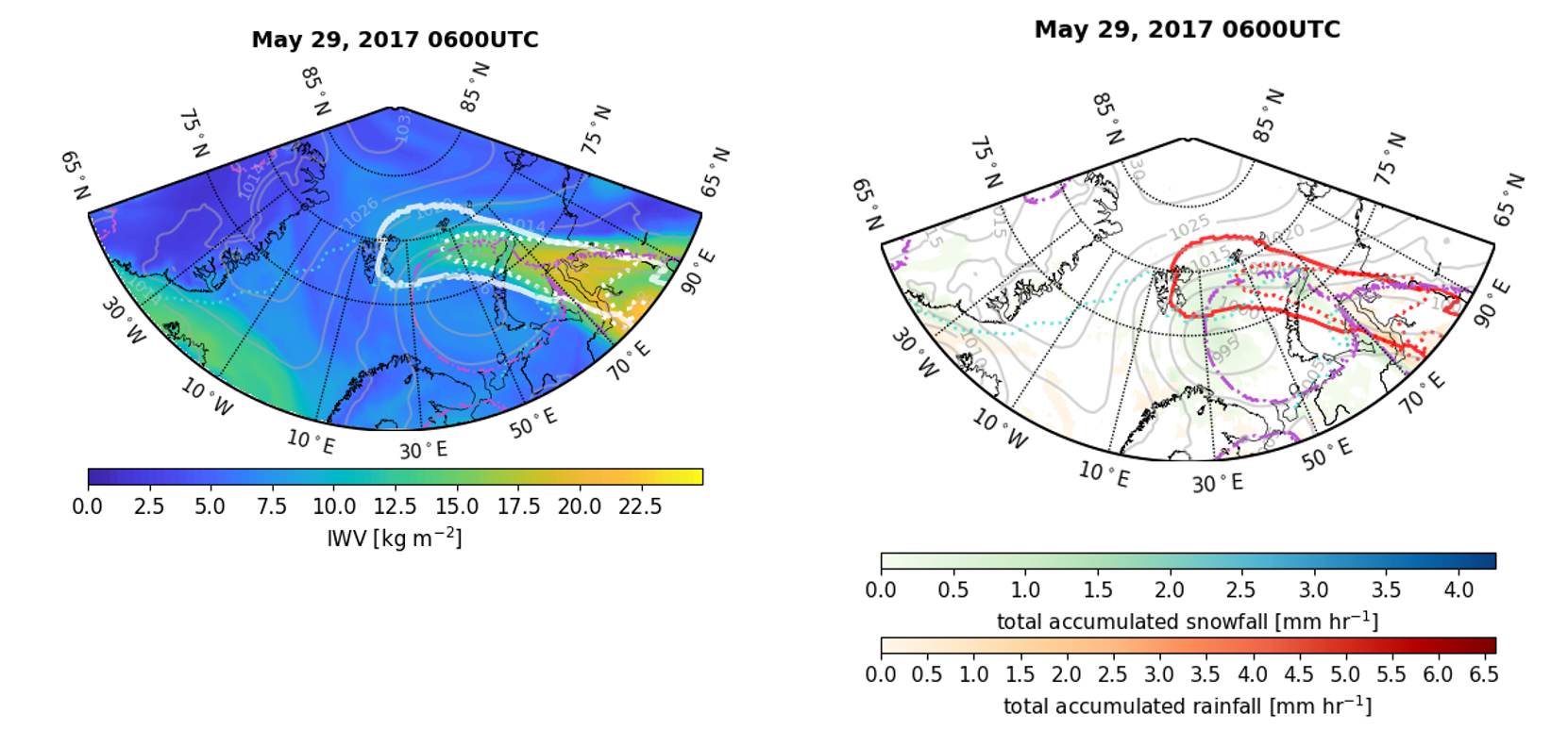
Example of an atmospheric river event, which is characterized by elevated vertically integrated water vapor (IWV), and is steered by a low pressure system – a cyclone – over the Barents Sea. The associated precipitation occurs within the atmospheric river shape, and also at the cyclone and its fronts.


HALO Project – Observing phase transitions in mixed-phase clouds using polarimetric and spectral imagery

PIs: Bernhard Mayer, Tobias Zinner (LMU)

Cloud observations by the polarized RGB camera of the specMACS instrument on May 16, 2019. The plots show the so-called degree of polarization Q. (Left) cloudbow and cloudglint are visible at the same time - mixed phase cloud top. (middle) only cloudbow visible - liquid cloud top (right:) cloudglint visible, cloudbow weak - hardly any liquid water in a icy cloud top.

Aim of this individual project is the characterization of the phase of mixed-phase clouds at high spatial resolution (better than 100 m) using a novel combination of spectral and angular passive remote sensing. The phase partitioning between liquid water and ice is targeted, using angular features specific for liquid water (cloudbow, backscatter glory) or ice clouds (cloud glint) and a combination with spectral characteristics (spectral slope in NIR). While the former angular features are only sensititive to the very top of the clouds, but unaffected by 3D radiative transfer effects, the latter spectral approach suffers from 3D effects, but is sensitive to large parts of the arctic cloud deck’s phase properties. This way, a complementary determination of temporal and spatial scales of the phase transformation in low-level Arctic stratus and stratocumulus during cold-air outbreaks and warm-air intrusions during HALO-(AC)³ is aimed for. Comparison with in-situ observations from the 2021 HALO mission CIRRUS-HL will be used to validate the new method.

HALO Project – Observing local and remote controls on Arctic air-mass evolution (ORCA2)

PI: Roel Neggers (Uni Cologne)

This project combines three recent developments in the atmospheric sciences, including (i) circular dropsonde sampling, (ii) Lagrangian air mass tracking and (iii) high-resolution Lagrangian simulation of Arctic mixed-phase clouds. The aim is to optimally benefit from their combination during the HALO-(AC)³ field campaign to gain insight into what controls the transformation of warm and moist air masses as they move into the high Arctic. The goal is to thus provide observational support for the important role played by remotely-controlled large-scale subsidence in the evolution of Arctic air masses as found in recent LES studies.

Large-Eddy Simulation (LES) of Arctic mixed-phase clouds observed by the Polarstern Research Vessel (RV) on 7 June 2017 during the PASCAL field campaign. Left: Volume rendering of cloud liquid water (shaded grey) and cloud ice water (colored shading). The domain size (white box) is 2.56 x 2.56 x 1.28 km, resolved at a spatial resolution of 10 x 10 x 10 m. Right: Vertical profiles of observed (black) and simulated (blue) water vapor qv, highlighting the cloud-free humidity layer that is capping the liquid cloud layer (shaded grey).

HALO Project – Investigating differences in ice cloud properties and effects in the Arctic due to warm meridional transport of moisture caused by warm air intrusions (ICE-Arctic)​

PI: Silke Groß (DLR-IPA)

The aim of the project is to characterize ice cloud properties in the Arctic as well as a possible modification of the ice cloud properties due to warm air intrusions. Therefore, lidar and radar measurements will be performed and analysed to characterise the ice cloud properties. The derived optical, macro- and microphysical properties will then be used to calculate the radiative effect of the different types of arctic ice clouds.

tbd

HALO Project – Understanding clouds and precipitation at the sub kilometer scale using HALO and ICON - Air mass transformations in the Arctic (UCP-Arctic)

Northward view on cloud streets developing within a cold air outbreak over the open ocean close to Svalbard (right) simulated by ICON-LEM.

PIs: Vera Schemann (Uni Cologne), Felix Ament (Uni Hamburg)

The HALO-(AC)³ airborne observations will be used to determine the moisture budget during warm air intrusions and cold-air outbreaks with a special focus on precipitation. The measurement information will be combined with high-resolution modeling to gain a better characterization of air mass transformations in the Arctic, which will enable to investigate the key processes and constrain numerical weather prediction and climate models. To reach this goal, high-resolution simulations will be used to forecast trajectories and based on these develop flight-patterns in the preparation phase and during the campaign.

HALO Project – Influence of the ice crystal shape on radiative effects of Arctic cirrus: Observations and representation in numerical weather prediction models

PIs: Manfred Wendisch, André Ehrlich (LIM)

Measurements of the cloud-reflected solar and emitted thermal infrared irradiance with the new BACARDI radiometer system and the SMART-Albedometer are proposed to quantify the radiative effect of Arctic cirrus. The observations will evaluate how well the cirrus and their radiative effects are represented in numerical weather prediction models. Operational and experimental radiation schemes will be tested and compared to the observed radiation. The planned evaluation of the ECMWF IFS radiation scheme ecRAD is illustrated.

Concept and design of the experiments planned for evaluating the ECMWF IFS accuracy by measured spectral and broadband irradiance and radiance. Numbers 1 to 4 indicate the individual steps of comparison.